 |
Map of Cebu, Philippines |
|

|
Moalboal, Philippines Site
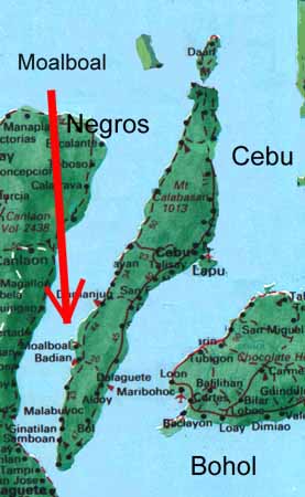
As
you can see, Cebu is a long, thin island with the international airport situated
on Mactan Island, just outside Cebu City on the east coast. There is a perimeter
road running most of the way round the island and if you look between Barilli
and Badian on the west coast, you will see Moalboal marked. There is a large
red arrow pointing there as well!
Cebu is about 30km wide at its widest point, and around 200km long, running from Bogo
(winner of the cleanest and greenest town in the Philippines for four successive years!)
in the north to Santander in the south. Cebu has a ridge of hills running down the central
spine which divide the west coast from the more populated east coast and is generally a dry,
sunny island (we had no rain in Moalboal between October 1997 and May 1998!) which means
that even the wet season here is less wet than in many other parts of the Philippines. As
in much of the Philippines, deforestation by greedy landowners is taking its toll and the
El Niño dry spell last winter hasn't helped - it's easy to still see the signs of
dead coconut palms as you drive anywhere on the island.
However the rains come and life returns to the earth quickly . . . .
That concludes our quick geographical tour of the Philippines, though with over 7000
islands, there are plenty more places to dive that even the locals have barely discovered yet!
You can see a little more of this with Google satellite photos of
Cebu Island.
